Northern Saskatchewan Summer High Water Update – September 11, 2020
Rainfall
Northern Saskatchewan has received extremely high cumulative precipitation since April 1, 2020, resulting in very high flows and lake levels across the Churchill River and Lower Saskatchewan River basins. Much of this rainfall has come in the months of May, June, and July, where accumulations at some sites have exceeded 200% of normal.
Most of the north received some showers over the past three days but accumulations have been less than 12 mm. Highest accumulations occurred east of Cree Lake up towards Stony Rapids. Accumulations over the Churchill River Basin were generally below 8 mm.
Flows and Lake Levels
High river and lake levels can be expected for the remainder of summer and in some cases, such as the mainstem of the Churchill River, into the fall and winter. The expected peak or observed peak throughout the system is generally slightly lower than previous historical highs. However, flows and levels in the Lower Churchill River, including Reindeer River and Churchill River near Sandy Bay, have exceed previous historical highs.
Below are specific conditions at various locations as well as projected future peak levels.
Île-à-la-Crosse:
Present elevation: 421.02 m
Levels at Lac Île-à-la-Crosse are continuing to decline; however, they will remain higher than normal for the remainder of the open water season and vulnerable to additional rainfall events and wind events.
Lac La Ronge
Current elevation: 364.91 m
Observed Peak: 364.95 m (August 10-30)
Over the past week, 8 mm or rainfall has been observed at La Ronge and accumulations ranging from 13-16 mm were observed over headwater near Montreal Lake. While this slowed inflow recessions some, the lake continued to decline.

Sandy Bay
Present Elevation: 8.80m (1910 m3/s)
Observed peak: 10.15 m (2420 m3/s) on August 4

Water levels at Sandy Bay reached a peak on August 4 and are now down about 1.35 m. Levels are now well below the 2005 peak. With flows upstream showing some slow declines, flows and levels at Sandy Bay will continue to decline slowly over the coming week.
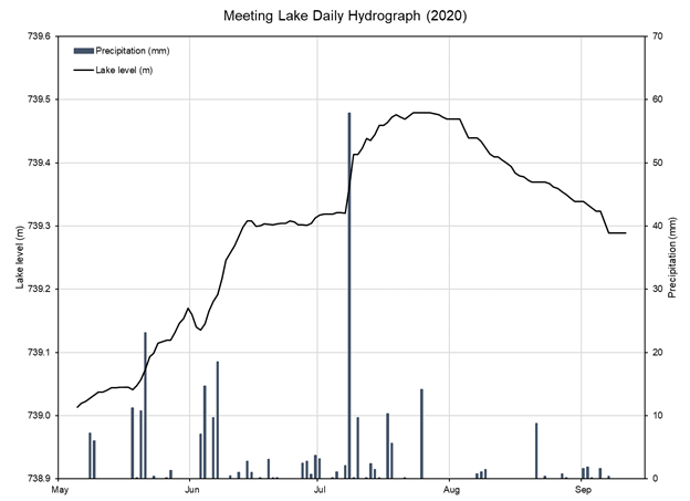
Meeting Lake
With warm and dry conditions over the past month, levels at Meeting Lake have been dropping. Only 19 mm of rainfall was observed since August 1 at Spiritwood, the closest observations we have to Meeting Lake, with no significant rainfall events over the past two weeks.
Present elevation: 739.29 m – September 11, 2020
Observed peak: 739.48 m – July 27, 2020
Jan, Amisk, and Deschambault Lakes
Jan Lake peaked in late July, 54 mm above 2017 levels.
While we do not have any current information for Deschambault or Amisk lakes, with the Sturgeon Weir River at Leaf Rapids receding Deschambault Lake has likely peaked and a peak at Amisk Lake can be expected soon if it has not already occurred. Like Jan Lake, peaks that are slightly above 2017 levels are expected at Deschambault and Amisk lakes, unless significant, additional precipitation is observed.
Future Rainfall
A surface low is expected to move from northern Alberta into northern Saskatchewan today. General accumulations of 5-20 mm are expected today through Saturday with localized accumulations of up to 30 mm possible where thunderstorms develop. This event is expected to impact areas north of the Churchill River, with highest accumulations over the SK-NWT border east of Lake Athabasca. As currently forecasted, this event is not expected to have any significant impacts to the areas of concern noted above. Following this event, drier conditions are expected over the next week.
For more information, contact
Patrick Boyle
(306) 631-6997